Somervell County
TSHA
Richard Elam
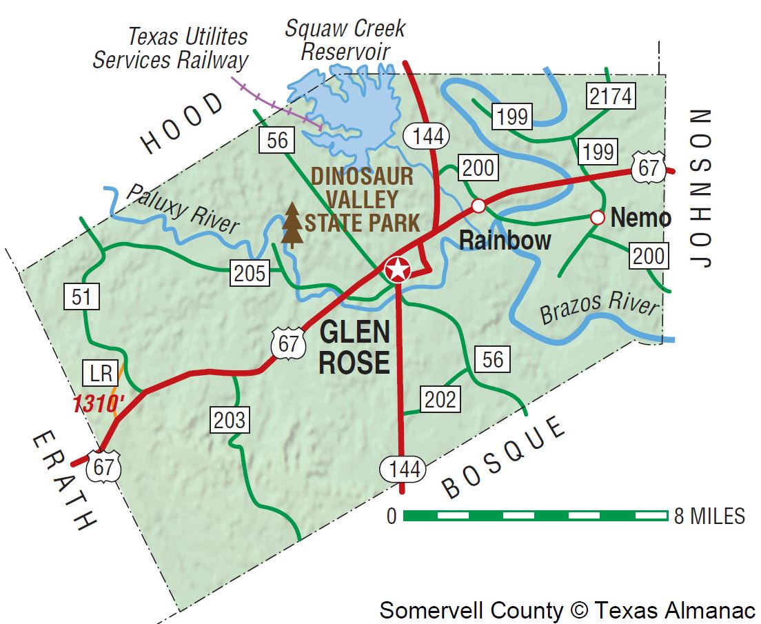 Somervell County is in north central Texas and is bisected by U.S. Highway 67 and State Highway 144. It comprises 188 square miles, the second-smallest area among Texas counties. Glen Rose, the principal town and county seat, is fifty-five miles southwest of Fort Worth. The county's center lies at 32°14' north latitude and 97°47' west longitude. The eastern half of the county is in the Grand Prairie region, while the western area is in the Cross Timbers. The primary soil type consists of very shallow, clayey soils in limestone. Other types include deep loamy and alluvial soils, especially along the river bottoms. Most of the land is used for range, though some is pasture and cropland. The only mineral resources are brick clay, limestone, road materials, and a small amount of natural gas. The overall terrain is generally rough with outcroppings of limestone. Native trees on the uplands include live oak, Spanish oak, mountain cedar, post oak, black jack, and mesquite. Cottonwood, pecan, bur oak, and black walnut can be found along the river bottoms. The elevation ranges from 600 to 1,200 feet. Three major streams traverse the county; the Brazos River winds through the eastern third, while the Paluxy River passes through the center and empties into the Brazos near its confluence with Squaw Creek. Temperatures range from a July average maximum of 98° F to a January average minimum of 32°. The average annual rainfall is 32.65 inches, and the growing season is 236 days long.
More than 100 million years ago dinosaurs roamed the area that is now Somervell County. The Paluxy River has some of the best-preserved tracks found in the continental United States. Much of the excavation on these tracks was done by Roland T. Bird of the American Museum of Natural History in New York. That museum, the University of Texas, the Smithsonian Institution, and several local museums retain samples. Local efforts to protect and preserve tracks imbedded along the river resulted in the foundation of Dinosaur Valley State Park, a 1,523-acre facility formally dedicated in 1970. Prior to European settlement of North America, the area was inhabited by American Indians, particularly members of the Caddo groups and Tonkawas. The southern edge of the Wichita Confederacy of Caddos extended into this area, although the Tonkawas were the major tribal group. Apaches and Comanches came into the area periodically. The first permanent Anglo settler was Charles E. Barnard, who established an Indian trading post in the late 1840s with his brother, George Barnard, for whom George's Creek was named. Charles's wife, Juana Cavasos Barnard, was the granddaughter of Don Narciso Cavasos, recipient of the largest Spanish land grant in Texas. She had been captured by Comanches in South Texas and ransomed by the Barnards. Barnard's Mill, built in 1860, was the first building at the site that is now Glen Rose. The mill is still standing and is listed on the National Register of Historic Places. During most of the 1850s and early 1860s the Barnard's Mill settlement was a part of Johnson County. In 1866 the area was included in a new county, Hood, marked off entirely from Johnson County. Somervell County was established in 1875, when residents in southern Hood and northern Bosque counties petitioned for a new county because of their separation from markets and seats of government. The county, taken completely from Hood County, was named for Alexander Somervell, who led an expedition to Mexico under the Republic of Texas. The first and only county seat is Glen Rose, named in 1872. Other early communities included Wilcox, Rainbow, Nemo, and Glass. The census of 1880 indicated a population of 2,649, with only 132 in Glen Rose. At that time Somervell County had a black population of twenty-four.
Glen Rose was the center of activity for the county during the last two decades of the nineteenth century. A Baptist college was organized in 1879 and sold to the Paluxy Baptist Association the next year. In 1889 the northern Presbyterians opened Glen Rose Collegiate Institute. Four periodicals were published in Glen Rose during these decades; the Glen Rose Citizen, the Glen Rose Falcon, and the Glen Rose Herald were local newspapers, while the Monthly Baptist Standard had a wider circulation. A public school system was started in 1896, eventually eclipsing the private college. In spite of the county seat's prominence, Somervell remained an agricultural county, the primary product being livestock. This may account for the importance of People's party politics. Although the county usually voted Democratic, third parties did have considerable support. In 1892 the Populist ticket carried Somervell County. The county entered the twentieth century with a population of 3,498. A tornado destroyed thirty-six buildings in Glen Rose in 1902. The population peaked at 3,931 in 1910 and then declined to a low of 2,542 by 1950. The county had twenty-one rural schools operating by 1910, and Glen Rose had become something of a health resort because of the local mineral springs. Over 600 farms were operational in 1910, but almost half of these were tenant run. During the 1920s the county gained a reputation as the "Moonshine Capital of Central Texas." In a move by the Texas Rangers in 1923 to clean out illegal liquor operations, forty local men were arrested including the county sheriff and county attorney. By 1930 the county had no black residents.
Although agricultural production during the Great Depression remained fairly constant, unemployment increased dramatically. In 1930 it was virtually nil; by 1935, however, the county had 143 workers on relief, and in 1940 approximately 15 percent of the workers were either on emergency work programs or were seeking work. New Deal programs provided some assistance. Glen Rose borrowed $80,000 under the Public Works Administration to construct a new water and sewage system. Three low-water dams on the Paluxy River, several local school buildings, and a canning plant were built with Work Projects Administration money.
The years after World War II ushered in major changes. Although the county was still primarily agricultural and rural, its proximity to the Dallas-Fort Worth area led to a rapid increase in industry that transformed it. Between 1940 and 1960 the number of farms was reduced by more than half, and agricultural production dropped. Corn and cotton acreage decreased significantly, and a shift occurred from dairy to beef cattle. By the 1970s the chief agricultural products were cattle and hogs. Major crops included peanuts, pecans, hay, and small grains. Only 8 percent of the available farmland was under cultivation in 1982, and the county ranked 249th in agricultural receipts that year. Somervell County had virtually no industrial development until that decade, but dramatic changes came with the construction of a nuclear power plant by the Texas Utilities Electric Company along Squaw Creek north of Glen Rose. The construction of this plant, begun in the mid-1970s, resulted in some important financial advantages for the county. By the mid-1980s the county had nearly $2 billion worth of taxable property, and $141 million in wages were paid annually, an 11,000 percent increase since 1975. Population growth also resulted. Between 1960 and 1970 the county grew by 8 percent, but the next census reflected a 49 percent growth rate; half the population of 4,154 lived in Glen Rose. Somervell County also benefited recreationally from the nuclear plant. Squaw Creek Reservoir, a 3,275-acre lake built by Texas Utilities to provide cooling water, has camping and fishing facilities at a 475-acre park across from the plant. Dinosaur Valley State Park and smaller city parks in Glen Rose offer additional recreational opportunities. The Texas Lakes Trail passes through the county, and annual events include a May Bluegrass Jamboree. In the mid-1980s the county had one weekly newspaper, the Glen Rose Reporter, one airport, and one school district with 800 students. Ten churches existed in the county. Somervell County was in a nexus of growth. Hood County, to the north, was the fastest-growing county in Texas between 1970 and 1980 and continued to experience dramatic growth in the 1980s. Johnson County, to the east, also experienced rapid growth. U.S. Highway 67 provided direct access to Dallas, and Fort Worth was less than an hour away. Comanche Peak Steam Electric Station provided a stable and substantial tax base. In 1990 the population of the county was 5,360, with Glen Rose (1,949) the most populous community.
In 2014 the census counted 8,694 people living in Somervell County. About 77.1 percent were Anglo. 1.2 percent were African American, and 19.1 percent were Hispanic. Almost 77 percent of the residents age twenty-five or older had graduated from high school, and more than 17 percent had college degrees.
The voters of Somervell County favored the Democratic candidate in virtually every presidential election from 1892 through 1948; the only exception occurred in 1928, when Republican Herbert Hoover took the county. After 1952, when Republican Dwight Eisenhower carried the county over Democrat Adlai Stevenson, the area began to trend Republican. Though Democrats won majorities in the county in 1964, 1968, 1976, and 1980, Republicans took the county in 1956, 1960, 1972, 1984, and 1988. Independent candidate Ross Perot won a plurality of the county's voters in 1992, and George W. Bush carried the county by large margins in 2000 and 2004.
In the early twenty-first century the Comanche Peak nuclear plant, agribusiness, and tourism were key elements of the area's economy; many residents commuted to jobs in the Dallas-Fort Worth area. In 2002 the county had 339 farms and ranches covering 84,262 acres, 65 percent of which were devoted to pasture, 26 percent to crops, and 7 percent to woodlands. In that year local farmers and ranchers earned $2,025,000; livestock sales accounted for $1,507,000 of the total. Cattle, hay, small grains, and goats were the chief agricultural products.
Communities included Glen Rose (population, 2,529), the county seat; Rainbow (121); and Nemo (56). Tourists travel to the area to enjoy Glen Rose Big Rocks Park, the Fossil Rim Wildlife Center, and a Passion play that runs from June through October.
BIBLIOGRAPHY: Raymond Elliott and Mildred Padon, Of a People and a Creek (Cleburne, Texas: Bennett Printing, 1979). W. C. Nunn, Somervell: Story of a Texas County (Fort Worth: Texas Christian University Press, 1975).
Handbook of Texas Online, Richard Elam, "SOMERVELL COUNTY,"
Somervell County Map. Courtesy of the Texas Almanac. Image available on the Internet and included in accordance with Title 17 U.S.C. Section 107.