|
|
|
|
Go To The Explanation and Abbreviations Page for Coleman County, Texas Cemeteries |
SANTA ANNA CEMETERY, COLEMAN COUNTY, TEXAS
The inscriptions for the Santa Anna Cemetery were originally recorded and up to date as of August 1, 1988. I am currently updating the Santa Anna Cemetery. Platt (Plot) I is current to February 23, 2002.
The Santa Anna Cemetery is located on the southeast edge of town on FM 1176. This is a large, well kept cemetery with two full time caretakers in 1988, employed by the cemetery association. For many years the cemetery was cared for by Bill and Doris Griffin and the stone near the entrance gate shows appreciation for their hard work.
According to a story in Beatrice Grady Gays book, "Into the Setting Sun," Frank Brooks tells that his father, W. C. Brooks, died before the railroad was built and was the first person buried in the cemetery (W. C. Brooks died in 1885). Frank's brother, Lewis Brooks, gave the land for the cemetery. If this is correct, it seems odd that there were no deaths (or at least no local burials) between 1877 (when Brooks first came to the Santa Anna Gap) and 1885. We have not located a marker for W. C. Brooks, so we assume it to be unmarked. There are markers for 1885, but none earlier noted, so this story seems to be correct. On May 2, 1899, the land for the original cemetery (Platt or Plot I - these divisions are called Plots on the cemetery map and Platts in the cemetery records) is shown in the Coleman County deed records (Book 42, page 55 and Book 43, page 64) is shown to have been platted and bought from J. P. Matthews by a group headed by H. A. Morse for about four acres, "reserving lots theretofore deeded." Since that time, more land has been added to the west, north, and east of this original cemetery.
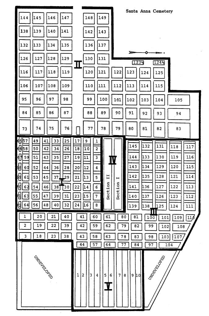
There is one gate into the cemetery on the west side of the cemetery from the highway. The road leading from the gate is actually a boulevard, at the end of which is the cemetery office, restrooms, and equipment storeroom. Most of Platts I, II, and III are laid out in blocks usually containing four lots, but sometimes contain less or more lots in odd corners of the cemetery. These lots sometimes run clockwise and sometimes counter-clockwise around its particular block. These blocks are separated by roads or lanes on all sides, creating a very orderly cemetery. In parts of Platts I and III, these lanes or alleys have been used as additional lots or blocks. The cemetery records refer to these as lots of the adjacent blocks, but in our reading, we have called them blocks. Platts IV and V are laid out in long sections containing lots. Stones in this cemetery were read by us in numerical Platt, block and lot order, rather than by rows. The map below indicates Platts, Sections, and blocks where space permitted. Numbers for the blocks created from lanes or alleys in Platts I and III have not been indicated on this map.
|
|
|
|
|
|
|
|