|
Coleman County
Historical Markers
(From A
History of Coleman County and Its People,
1985 (Coleman
County Markers added since 1985 are added in
list at the bottom of page)
The Texas
Historical Commission is responsible for awarding
Texas Historical Markers as applied for by the
County Historical Commissions. Under the
current program, the financing and research for a
marker is provided on the county level, usually by
members of the local commissions.
Applications are then approved by a state marker
committee composed of members of the State
Commission. A marker or medallion cannot be
placed on historic properties without the
consent of the owner.
An extensive historical marking program primarily aimed at recording events relating to the Texas War for Independence was carried out during the Texas Centennial in 1936. The Centennial commission was also responsible for the initiation of many outstanding and long lasting projects which included memorial buildings, some still in operation as museums. such as Coleman County's own County Museum. Following is a list of markers that have been located in Coleman County with their plate inscription (Or explanation, if no inscription), date of placement, location, and type of marker in code. Codes: (1) - 1936 Texas Centennial Markers and Texas War for Independence Markers erected by the state; (2) - Civil War Markers, erected by the state especially for the Civil War Centennial, 1961-1965; (3) - Texas Historical Markers and Recorded Texas Historic Landmarks, also granite historical markers, erected by the state; (4) - Private, state-approved markers. Ruins of Camp Colorado
"Originally
established on the Colorado River by the United
States Army as a protection for the frontier
against Hostile Indians - Moved in August, 1856,
to this site Abandoned by Federal Troops
February 26, 1861 - The site became the property
in 1870 of Henry Sackett(1851-1928), who built
his home here in 1879 - From here he, with
Maltby's Rangers, in 1874, pursued the bands of
Big Foot and Jape, Comanche Chiefs, and defeated
them." (1936) (1) Located 12 miles northeast of
Coleman off State Highway 206.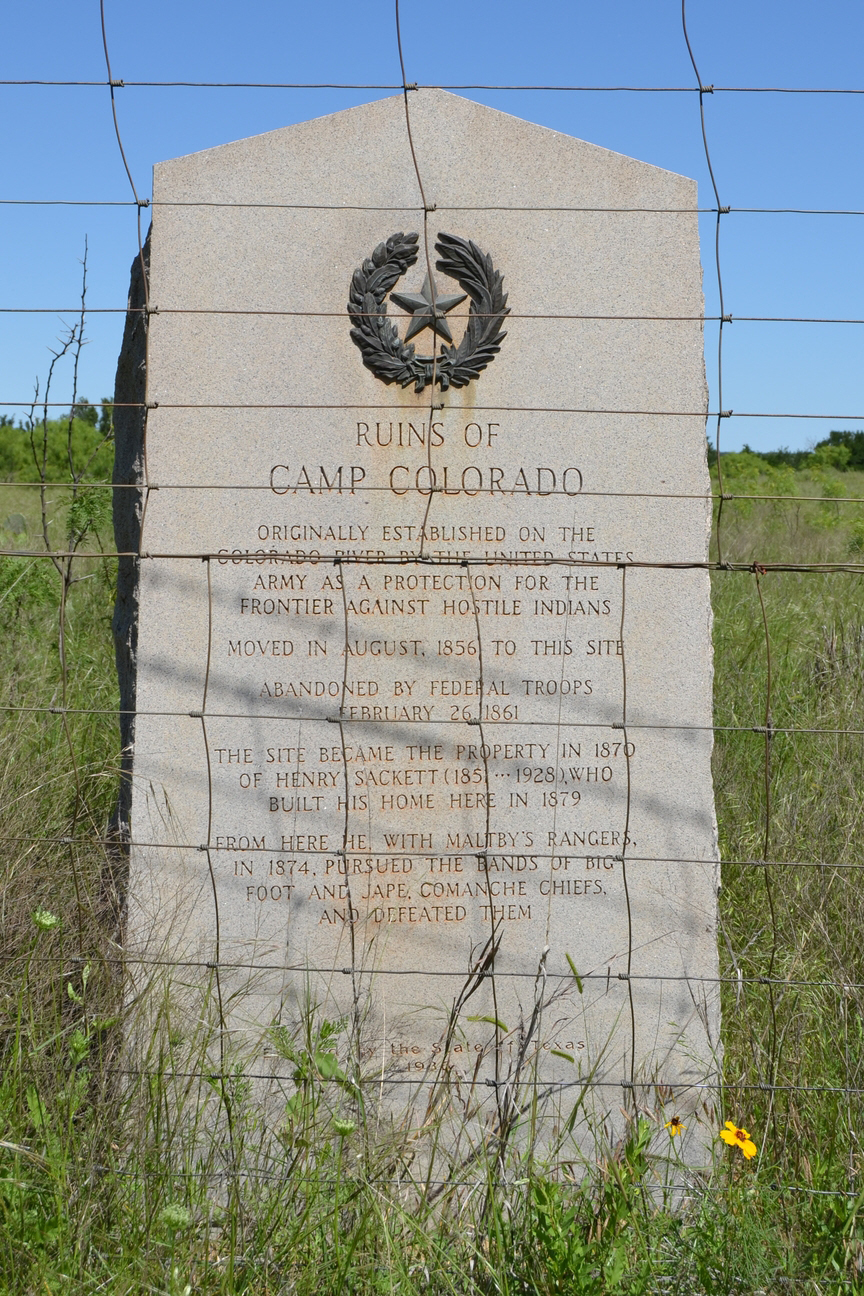 Marker at the site of Camp
Colorado
(photographed by Duane Hall, May 3, 2016) 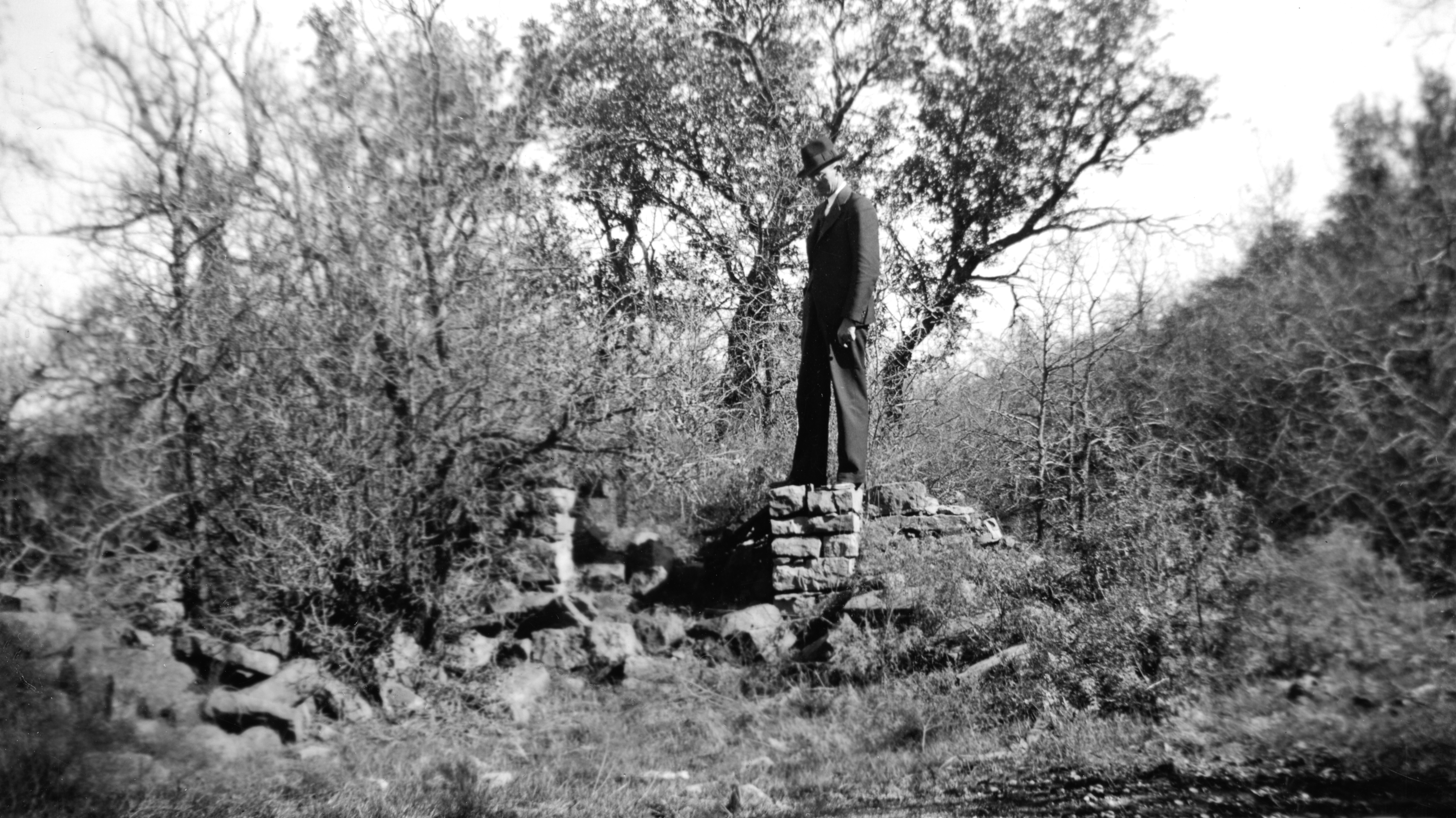 Ruins of Camp Colorado, 1936
Surveying the site before building the headquarters replica at Coleman City Park 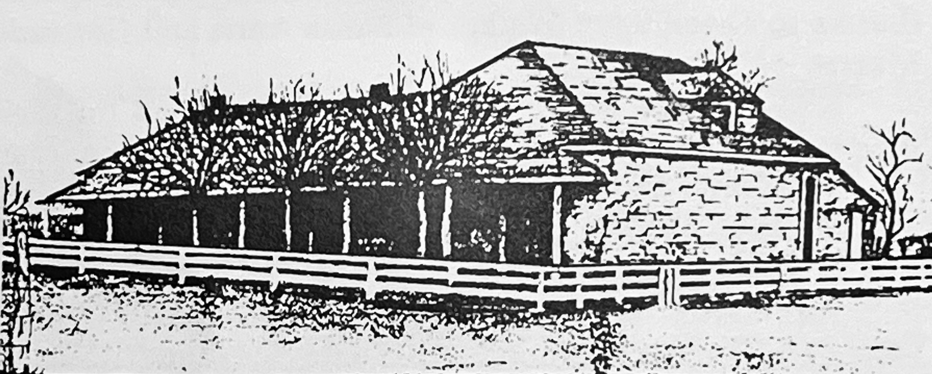 Drawing of Sackett Home at Camp Colorado by J. B. Brooke "Formed from Travis and Brown Counties - Created February 1, 1858; organized October 6 1864 - Named in honor of Robert M. Coleman (1799-1837), a signer of the Declaration of Independence, a hero of San Jacinto, organizer of first company of Texas Rangers - Coleman approved as county seat April 28, 1876." (1936) (1) NOTE: Two markers with this inscription were placed - one .6 mile north of Coleman on US 84 at a roadside park, and the other 3 miles northeast of Santa Anna on US 84, also at a roadside park. Both of the plates were stolen, due to the bronze metal used at that time - the stone and 1986 medallion of the one north of Coleman remain, but the one north of Santa Anna was removed to a location in front of the old Ranger Park at the east end of the Santa Anna Mountain, and in 1965 a new plate was made up and the medallion was restored - the new plate reads: "In early Texas had Apache,
Comanche, Kiowa camps and mountain lookouts -
White settlement began at Camp Colorado, U.S. 2nd
Cavalry Post, on Jim Ned Creek, 1857 - County was
created February 1, 1858 - Named for Robert M.
Coleman (1799 - 1837), a signer of Texas
Declaration of Independence and a hero of the
Battle of San Jacinto - To the south part of
county, 1862, came John Chisum, to raise cattle to
be furnished to Confederate Troops fighting Civil
War - County was organized October 6, 1864 -
Courts first met at Camp Colorado - Coleman was
approved as county seat April 28, 1876." (1965)
 Coleman County Marker - at Ranger Park, Santa Anna (Photographed by Ralph Terry, 1983) 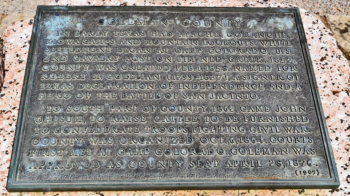 Coleman County Marker - at Ranger
Park, Santa Anna
(photographed by Duane Hall, 2016) Camp Colorado, C.S.A.
"Surrendered as U.S. outpost beginning Civil War - Became part frontier defense line from Red River to Rio Grande - Headquarters first Texas Mounted Rifles 1861 and Texas Fronter Regiment 1863 - Manned by troops and rangers in state and C.S.A. service to war's end - Valuable duty performed while patrolling and scouting to curb Indian raids and in rounding up draft evaders, deserters - Camp life difficult with constant peril of Indian attack, shortage food, ammunition, supplies and horses - Located 12 miles northeast - - - A memorial to Texans who served the Confederacy." (1936) (1) (Located in Coleman City Park) 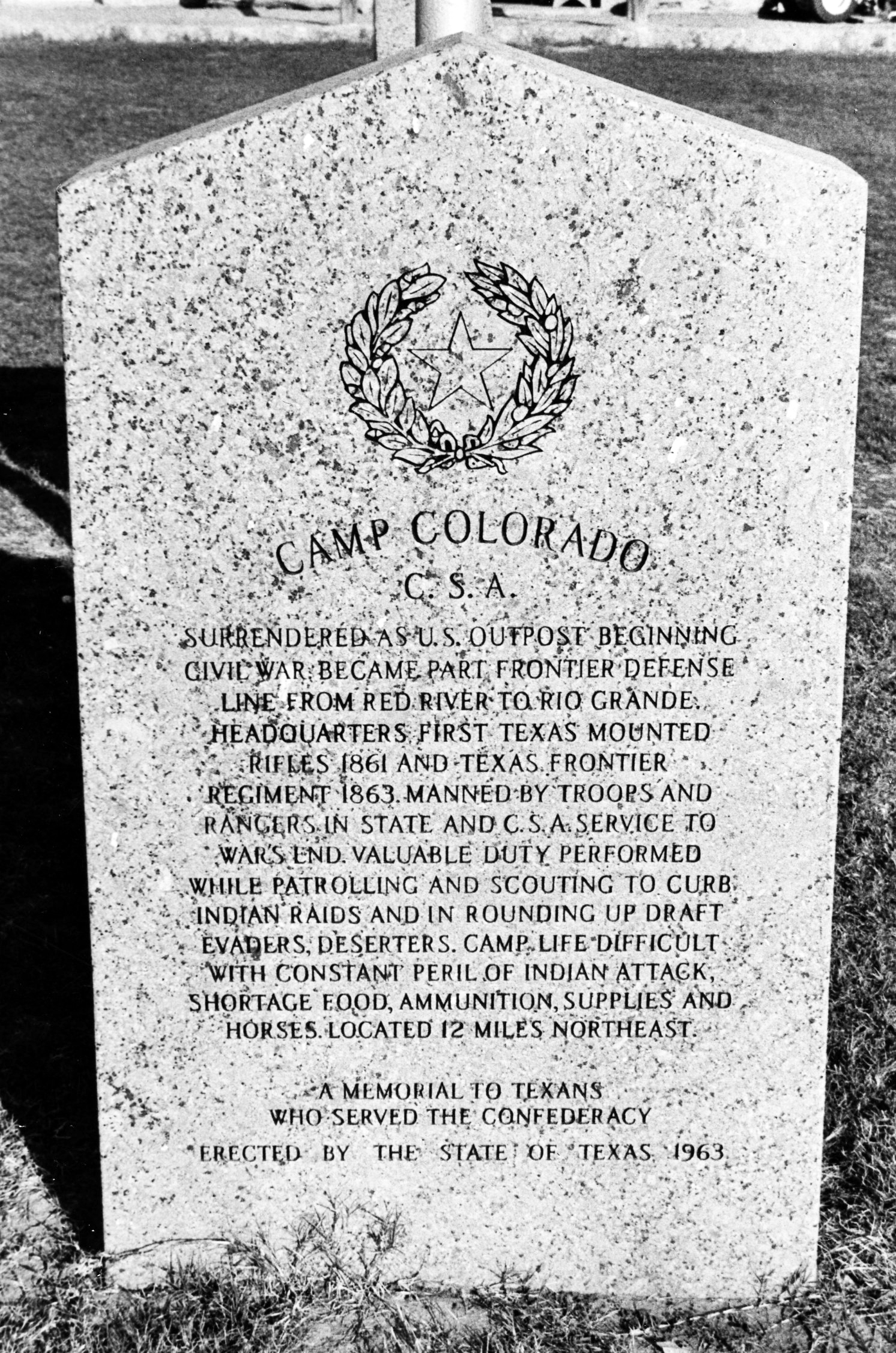 Camp Colorado Marker
(Photographed by Ralph Terry, 1983) Home Town of Texas
Confederate
Colonel James E. McCord (1834 - 1914) "South Carolinian came to Texas
1853 - Surveyor of lands in this region
including the site of Camp Colorado - Texas
Ranger - Prominent Secessionist - Member of
Texas State troops at start of Civil War • Lt.
Colonel of Texas Frontier Regiment established
1862, morale was low among these rugged
frontiersmen who disliked the discipline and
chain of command of Army life - Indians had
learned the system of regular patrols between
posts and slipped through to plunder - Draft
evaders and deserters, another threat to peace,
were flocking to the frontier and stealing from
the settlers - Some Coleman County families
stayed near Camp Colorado for safety - In 1868
McCord was unanimously elected colonel in
command of the regiment - He operated it as
Ranger unit - Abolished regular patrols in favor
of unexpected scouting expeditions to surprise
Indian raiding parties - With these changes, the
regiment's effectiveness increased - In late
1863 a new frontier defence system was initiated
McCord's regiment was taken into Confederate
service as the 46th Texas Cavalry • With the
immediate threat of Union invasion from
Louisiana and Arkansas, part of the 46th with
McCord leading was sent to east Texas, defenses
remaining until war's close • Prominent county
pioneer, businessman, - buried Coleman Cemetery
(1964) (2) (Located in Coleman City Park)
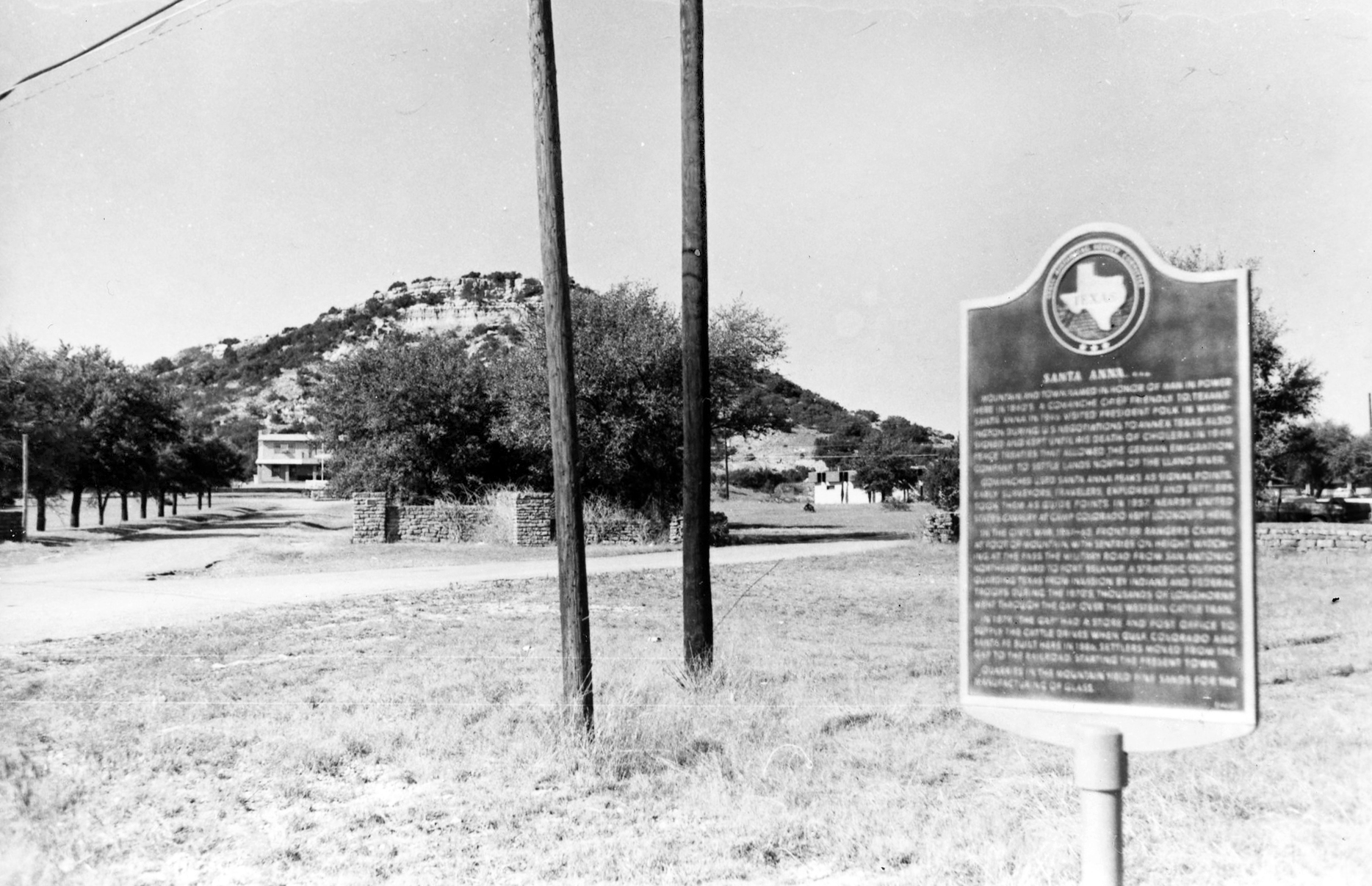
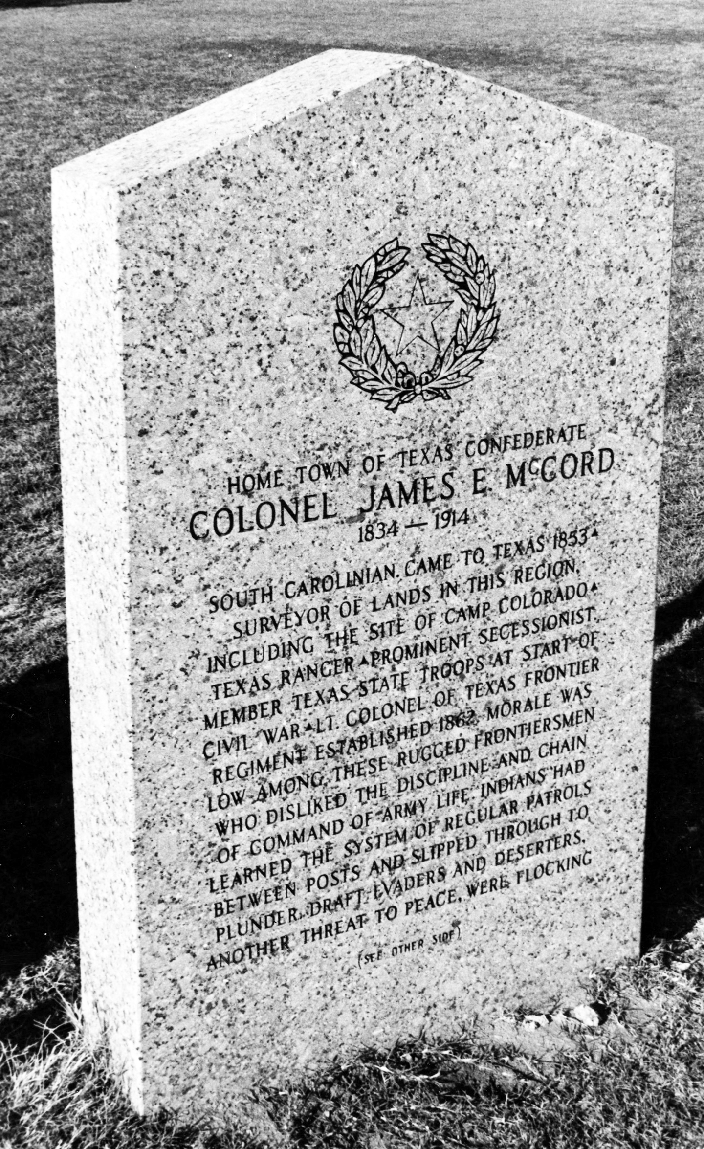 Colonel James E. McCord Marker (Photographed by Ralph Terry, 1983) Santa Anna, C. S. A. "Mountain and town named in
honor of man in power here in 1840's, a
Comanche chief friendly to Texans Santa Anna
in 1846 visited President Polk in Washington
during U.S. negotiations to annex Texas - Also
signed and kept until his death of cholera in
1849 peace treaties that allowed the German
Emigration Company to settle lands north of
the Llano River - Comanches used Santa Anna
peaks as signal points - Early
surveyors, travelers, explorers
and settlers took them as guide points - In
1857 nearby United States Cavalry at Camp
Colorado kept lookouts here - In the Civil
War, 1861-65, frontier rangers camped at foot
of mountain, with sentries on height watching
at the pass the military road from San Antonio
northeastward to Fort Belknap, a strategic
outpost guarding Texas from invasion by
Indians and Federal troops - During the
1870's, thousands of longhorns went through
the gap, over the western cattle trail - In
1879, "The Gap" had a store and post
office to supply the cattle drives - When
Gulf, Colorado, and Santa Fe built here in
1886, settlers moved from the gap to the
railroad, starting the present town - Quarries
in the mountain yield fine sands for the
manufacture of glass." (1965)
(2) (Located on US 84 at Ranger Park
entrance, east edge of Santa Anna) (this
marker was removed during highway
construction and stored by the Texas
Highway Department for many years ...
lost, in fact. When it was
relocated, it was placed in front of the
Santa Anna City Hall.)
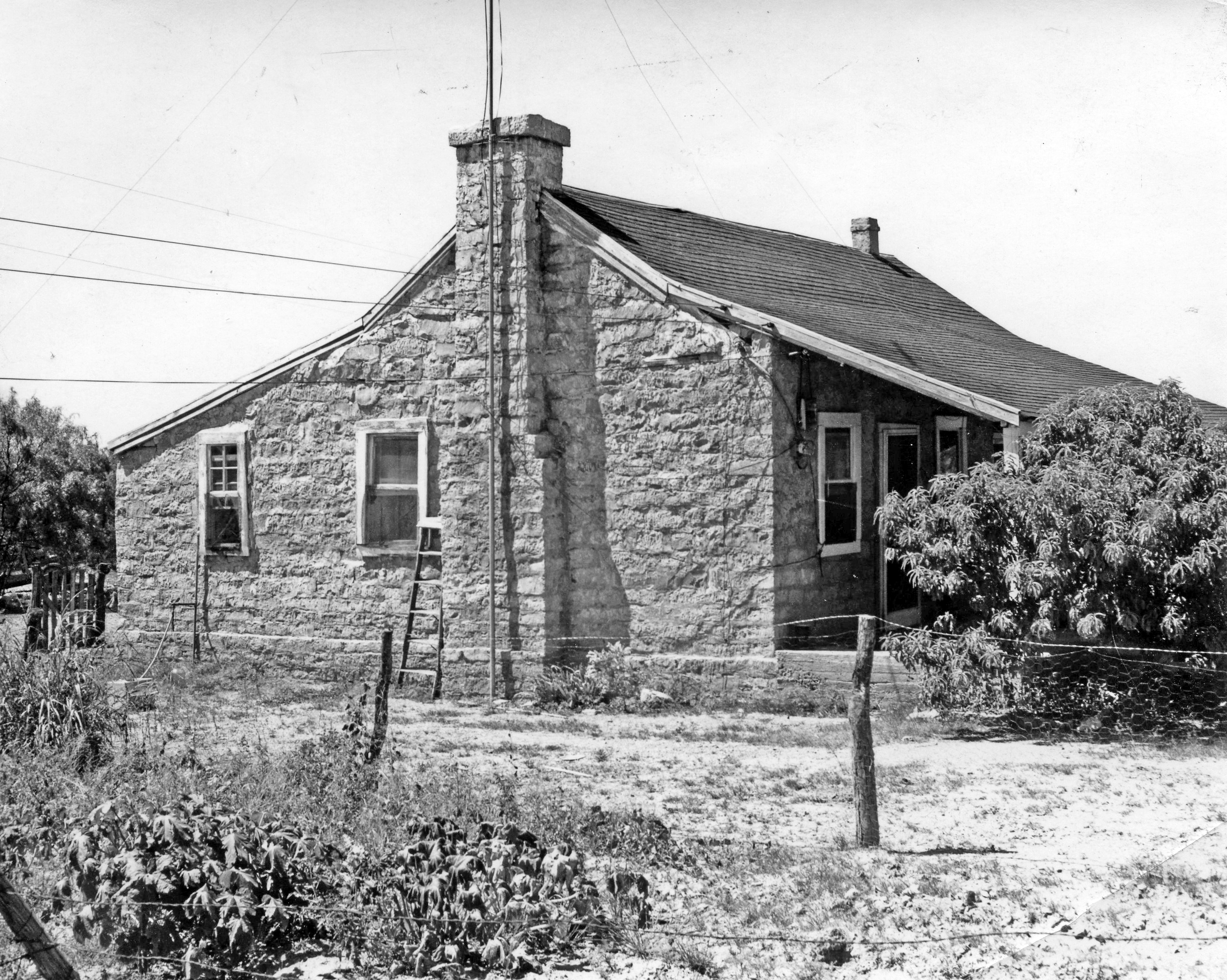
Camp Colorado Guard House No inscription - this is the only
original building left at Camp Colorado, built
in 1857. When Sackett bought the place, he
built his house by attaching it to this small
structure - the medallion has been removed by
the present owner, due to sightseers. (1965) (3)
(Located 12 miles northeast of Coleman off State
Highway 206)
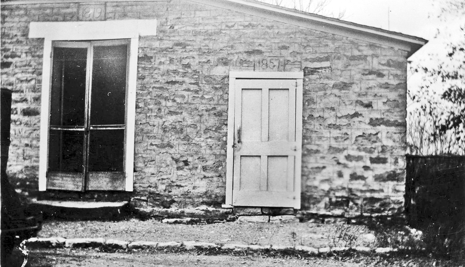 Camp Colorado Guard House Kin Elkins Home
No inscription - Kin Elkins was a
noted Indian fighter and cowman, settled near
Camp Colorado in the late 1850's. Two daughters,
Mary married Clay Mann and Martha married Jim
Jackson...Elkins died at the age of 94 in New
Mexico... The house was bought by J. F. Gordon
and is now owned by his son, Dr. Jack M. Gordon
of Coleman. .. The house originally consisted of
a double log house, connected by a wide open
hall with the large fireplaces set at each end;
later additions to the house enclosed the
original building, but the two log rooms were
left as they were built, being covered with
lumber, which makes the walls about ten inches
thick...It was thought that the log house was
built about 1870. (1965) (3) (Located 10 miles
northeast of Coleman off State Highway 206.)
 Drawing of the Kin Elkins Home by Mollie Grady Kelley in "Into the Setting Sun" County named in 1857 for Robert M. Coleman (1799-1837) "Born in Kentucky - Came to Texas
in 1832 - Commanded company of volunteers at
seige of Bexar (San Antonio), December 5-10,
1835 - Delegate to Constitutional Convention
where he signed Texas Declaration of
Independence, 1836 - Aide-de-camp to Gen. Sam
Houston at Battle of San Jacinto, 1836 - Later
fought Indians as a Texas Ranger." (1966) (3)
(Located on Coleman Courthouse
Square).
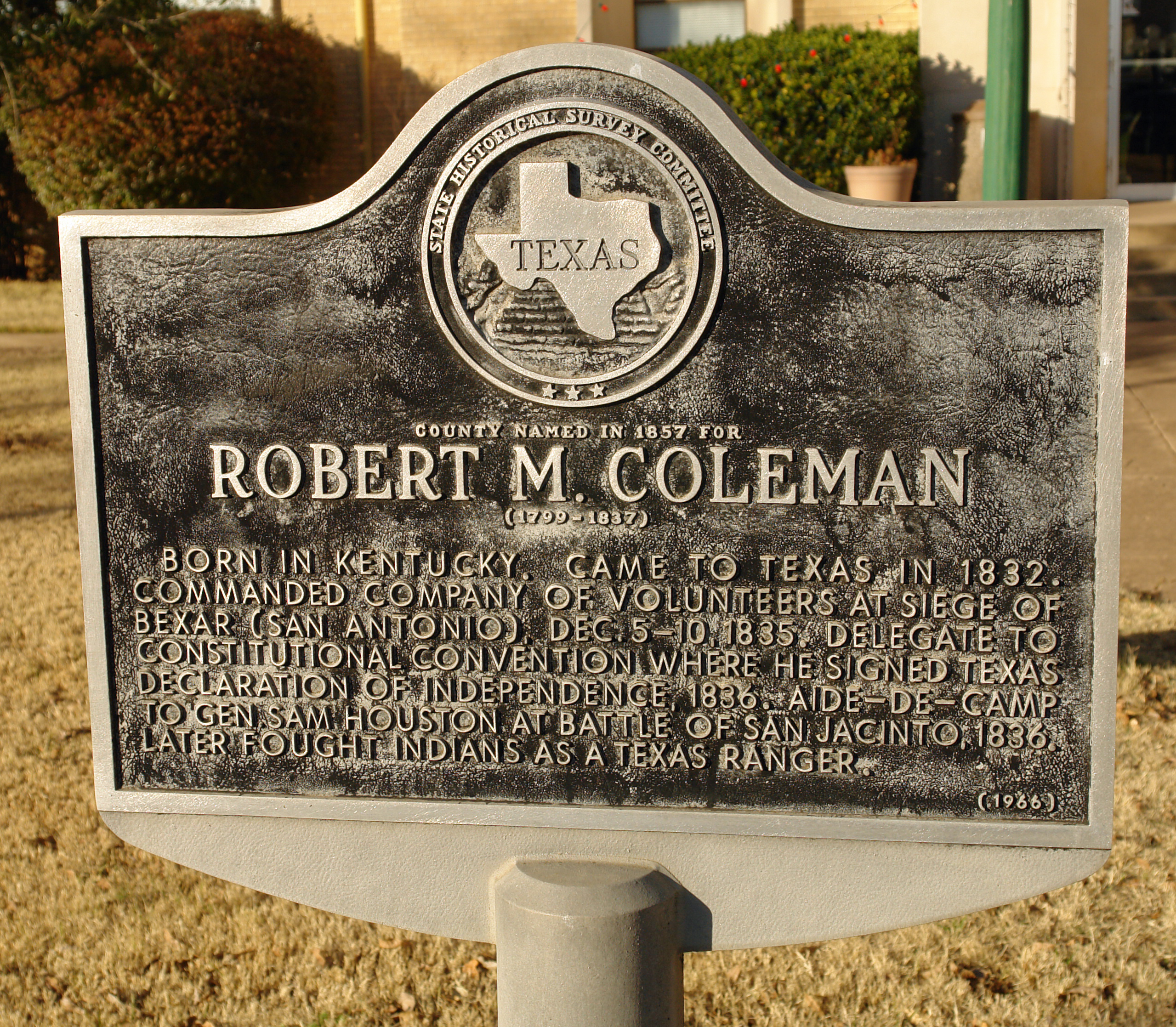 Texas Historical Commission Marker (Photographed by Ralph Terry, 2003) Old Day Ranch Headquarters (Rock House) No inscription - The house was
built by Bill McAuley, a son-in-law of Rich
Coffey in the early 1870's and sold to Col.
William H. Day, when he purchased large land
holdings in that area in 1876. This house has
been lived in continuously since built and is
now owned by the James T. Padgitt
family. (1967) (3) (Located about 4 miles north
of Leaday on a dirt road.)
 Old Day Ranch Headquarters [Rock House] The Turner House "Built 1886 by an attorney from
Mississippi - Colonial architecture - House
was enlarged from 8 to 12 rooms after 1903
purchase by Fred W. Turner, rancher and oilman -
This
was gathering place for area social and business
leaders." (1968) (3) Located in west part of
Santa Anna on US 67.)
 ) )Fred Turner Home (Photographed by Ralph Terry, 1983) Richard A. (Dick)
Pauley
(March 26, 1882 - May 16, 1925) "A man who achieved boyhood wish to become a law officer - Pauley was a rancher before his election in 1923 to office of Coleman County Sheriff - He was widely respected as a true gentleman - Often he did not carry a gun, preferring to convince fugitives that the law would protect, not hurt, them • He was shot by 2 stowaways while investigating a train car - His wife Kate Dancer Pauley and son Russell survived him." (1968) (3) (Located at the Valera Cemetery.) 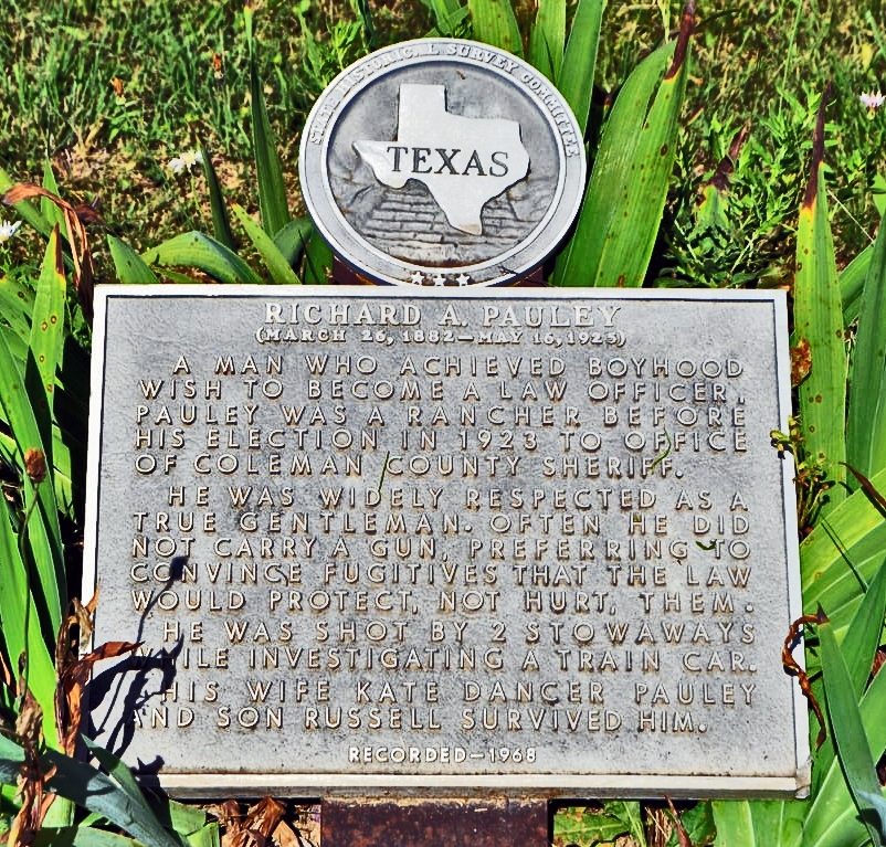 Richard A. Pauley Marker at Valera Cemetery (photographed by Duane Hall, 2016) Town of Trickham "Oldest town in the county -
founded about 1855 as a cowboy trading post for
ranching activities of cattle baron lohn Chisum
- During 1860-1890, it was a boisterous
community at a crossroads of cattle trails -
Because of notorious jokes played at local
general store, "Trick'em" was suggested for name
of post office here." (1969) (3) (Located at
Trickham on FM 1176.)
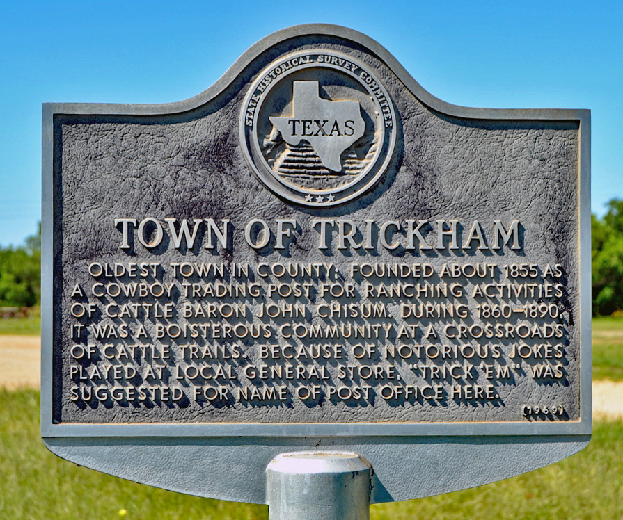 Town of Trickham Texas Historical Marker #4054 (photographed by Duane Hall, 2016) Site of Flat Top Settlement "A frontier center of traffic and
communications - First known settler,
Richard Coffey, lived here in 1860's, except in
weeks when pioneers banded together in
Picketville Fort (NW of here) for protection
against Indians - This was on the "wire road" -
so named because it followed telegraph line
operated by U.S. Army Signal Corps between Fort
Concho and Fort Belknap in the 1870's - Also in
1870's, Flat Top was a change station on Fort
Concho - Brownwood Stage route - Name of the
settlement came from a flat-root stone building
standing here in early days." (1969) (3)
(Located 4 miles southwest of Voss on
FM 2134
 Flat Top Settlement - Texas Historical Commission Marker (photographed by Duane Hall, 2016) 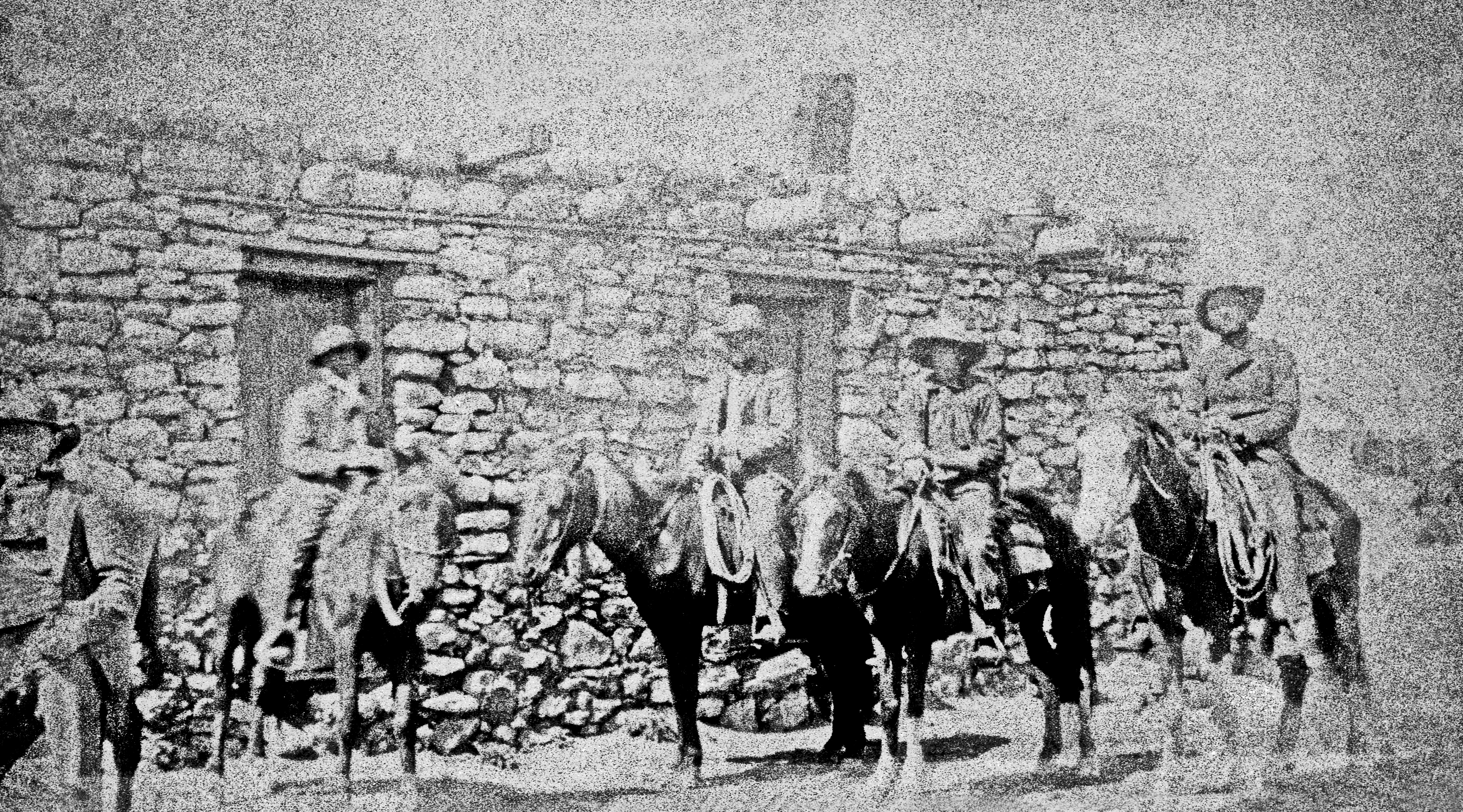 1860s Coleman County photograph of a house or stage stop at Flat Top or Camp Colorado. 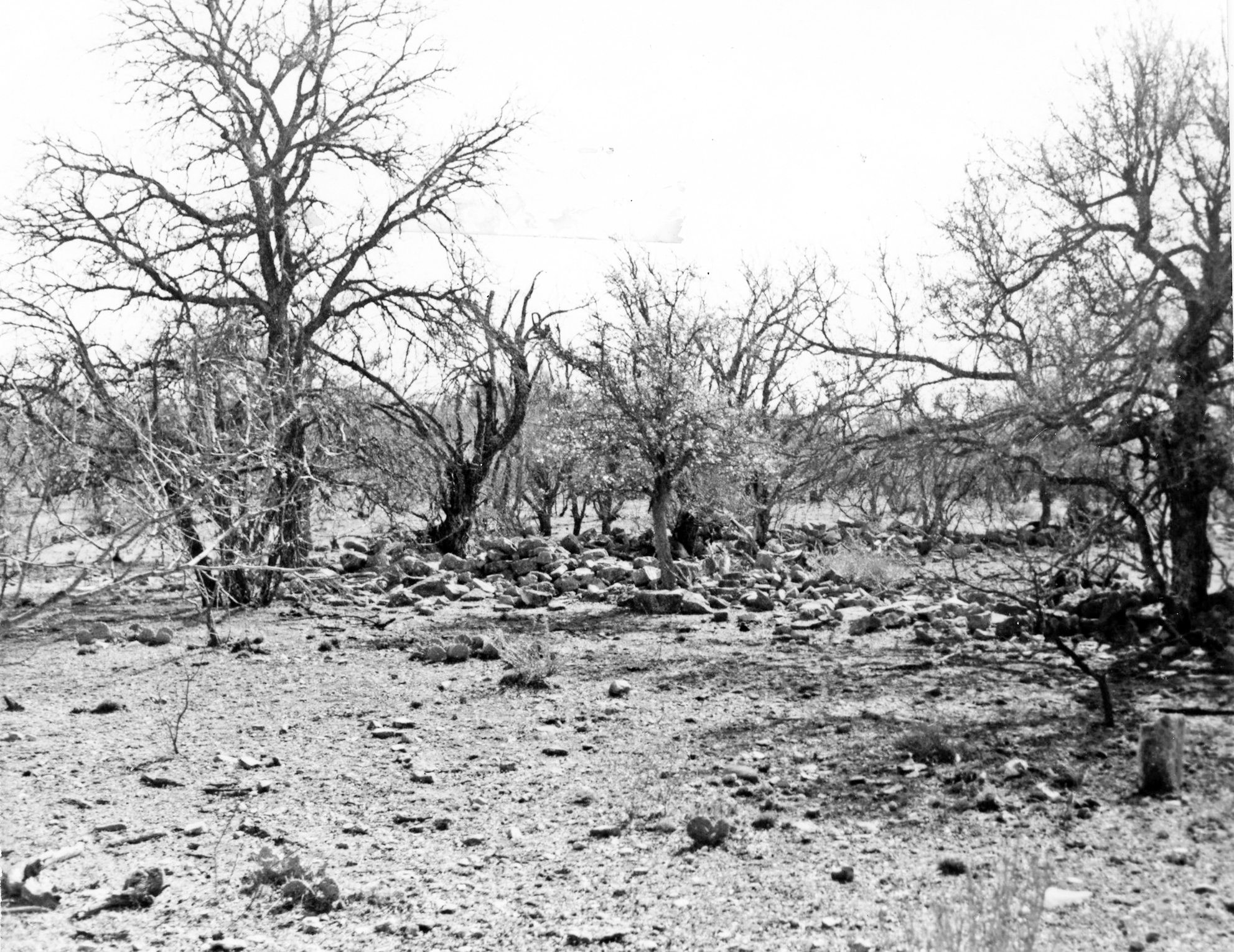 Some of the rock corrals at Flat Top - 1983 Coleman County Jail "Second county jail - (First was a
small 1879 structure on lawn of courthouse.)
- Erected in 1890, this building is a good
example ot Victorian jail architecture with some
traces of Romanesque Revival - Belting at ground
and second floors a notable detail - Lower floor
contains living quarters for the jailer - Upper
floor houses both maximum and minimum security
cells - only one person, a convicted murderer,
was ever hanged here." (1970) (3) (Located on
the Coleman Courthouse Square.)
(Pictures to be added) Cleveland - Anson House "First fine house in area - Built
in 1880 by George P. Cleveland, a sheep
rancher - Structure of native stone and lumber
hauled from Fort Worth by ox-wagon, has two-foot
walls - Second owner was Englishman Billy Anson,
son of the Earl of Litchfield." (1970) (3)
(Located on southwest edge of Valera on dirt
road.)
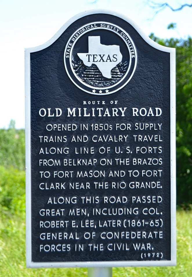
 Cleveland - Anson House - 1907 Route of Old Military Road "Opened in 1850's for supply
trains and cavalry travel along line of U.S.
forts from Belknap on the Brazos to Fort Mason
and to Fort Clark near the Rio Grande - Along
this road passed great men, including Col.
Robert E. Lee, later (1861-65) General of
Confederate forces in the Civil War." (1972) (3)
(Was located 3 miles east of Santa Anna, but was
moved when US 84 was widened, and has not been
replaced by the Texas Highway Department by
1985). By 2016, the marker had
been relocated at the intersection of US 267
and FM Road 567, on the north side of the
road, in the northwest corner.
 Old Military Road Marker (photographed by Duane Hall, 2016) Mr. and Mrs. W. P.
Williams
"William Patrick Williams (ca. 1818-1898) and his wife Elizabeth (Boles) (ca. 1822-1899) migrated to Texas: from Mississippi during the Civil War - After a brief stay in Cherokee County, they settled in this area, arriving by wagon train - Their nearby homestead became the nucleus of the neighboring rural settlement, the site of an early school they helped establish - The Williamses and their six children survived many hardships, including Indian raids and a smallpox epidemic - William, often called "Mukewater Bill' for a stream near his home, was a pioneer area leader." (1981) (3) (This marker was originally located at the Fiveash Cemetery in 1974, but due to a family dispute, the original marker was replaced with newly worded marker in 1982 and placed at Trickham, next to the Town of Trickham marker.)  Mr. and Mrs. W. P. Williams Marker (Photographed by Ralph Terry, 1983) Old Rock House
This site was claimed in 1857 under a Republic of Texas land certificate held by former State Representative Darwin Stapp of Victoria County - In 1869 he sold the tract to another absentee owner - By tradition, this house was built in the 1870's by John I. Brestow, a squatter who came to this area for his health - The one-room cabin was constructed of stone from the nearby Santa Anna mountains - Later owners, including Mrs. Sarah Himmins rented the property to tenant farmers - Mr. and Mrs. C. D. Bruce, who purchased the land in 1947, restored the rock house and maintain it now as a museum." (1975) (3) (Located one mile northwest of Santa Anna on US 84.)  Old Rock House - 1977 (Photographed by Ralph Terry, 1983) First Christian Church
of Santa Anna
"Founded in 1894, this congregation worshiped in various places until members purchased this lot in 1900 and began construction of their own building - The Rev. E. M. Douthit and the Rev. B. B. Sanders led the dedication ceremonies in April 1901 - A solid brass bell hangs in the off-center entry tower and spire that dominates this frame church - The interior has original beaded ceiling and wainscoting - The kerosene lamp in the vestibule has been converted to electricity." (1976) (3) 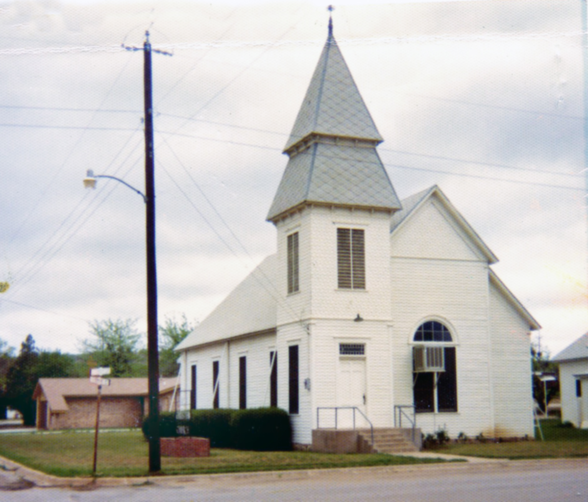 The First Christian Church of Santa Anna (Photographed by Ralph Terry, 1983) Mrs. J. A. B. Miller Public Library Building "Financed by the Self-Gulture Club
and other women s organizations, this
structure was erected in 1909 to provide a
meeting place for the groups and to house the
city's library collection - In 1924 when money
was no longer available to pay a librarian,
Mattie B. (Mrs. J. A. B.) Miller
(1874-1969), pioneer ranch woman and civic
leader offered her services - For 41 years, as
an unpaid librarian, she dedicated her time and
resources to the project - In 1968 when the city
took over operation, the library was named in
her honor." (1977) (3) (Located on the Coleman
Courthouse square.)
 Mrs. J. A. B. Miller Public Library Building (Photographed by Ralph Terry, 1983) The Blair House "A native of Georgia, J. T. Blair
(1876-1949) migrated to this area in 1897 - He
married Carrie Agnes Love, of a pioneer Coleman
family - They had five children - Blair served
as foreman of the Overall Ranch property - In
1914 he built his own residence in town so his
children could attend Coleman schools - Designed
by architect J. P. Caldwell, the classical
revival home was owned for 60 years by the Blair
family." (1978) (3) (Located in Coleman at
416 West College Avenue.)
The Blair House (Pictures to be added) D. A. Parker House "A native of Ohio, David Absalom
Parker (B. 1849) came to Coleman in 1876 with
his wife, Nannie Rachel (Atkinson)
- Soon after, they constructed this two-story
stone residence - Parker became a prominent area
cattleman and helped establish the town of
Novice when rail lines were built to the area in
1910 - The owner of a general store and cotton
gin, he was instrumental in the formation of a
school, church, and post office." (1983)
(3) (Located 2 miles west of Novice, about
1 mile south of FM 1770.)
 D. A. Parker House Old Western Trail Marker "This tablet commemorates the
Western Cattle Trail that passed through
Coleman in 1867-1895 - "Up The Trail' - Erected
by the Capt. Wm. Buckner Chapter D.A.R."
(1925) (4) (Located on the Coleman Courthouse
Square)
 Western Trail Marker on new stone (Photographed by Ralph Terry, 1983) 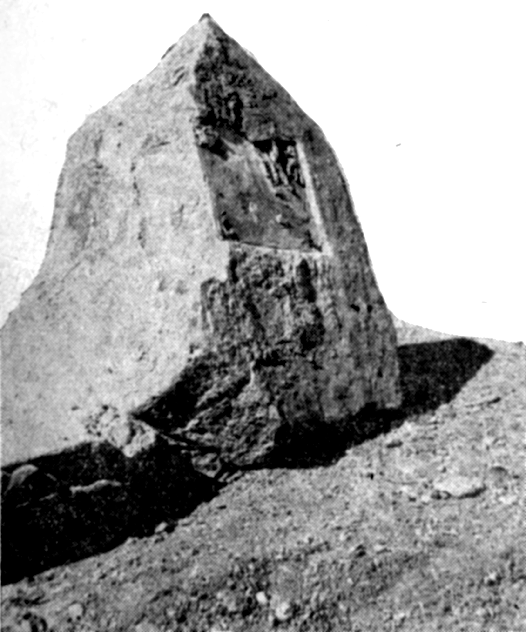 The original stone on which DAR's Western Trail Marker was located 1925-1952 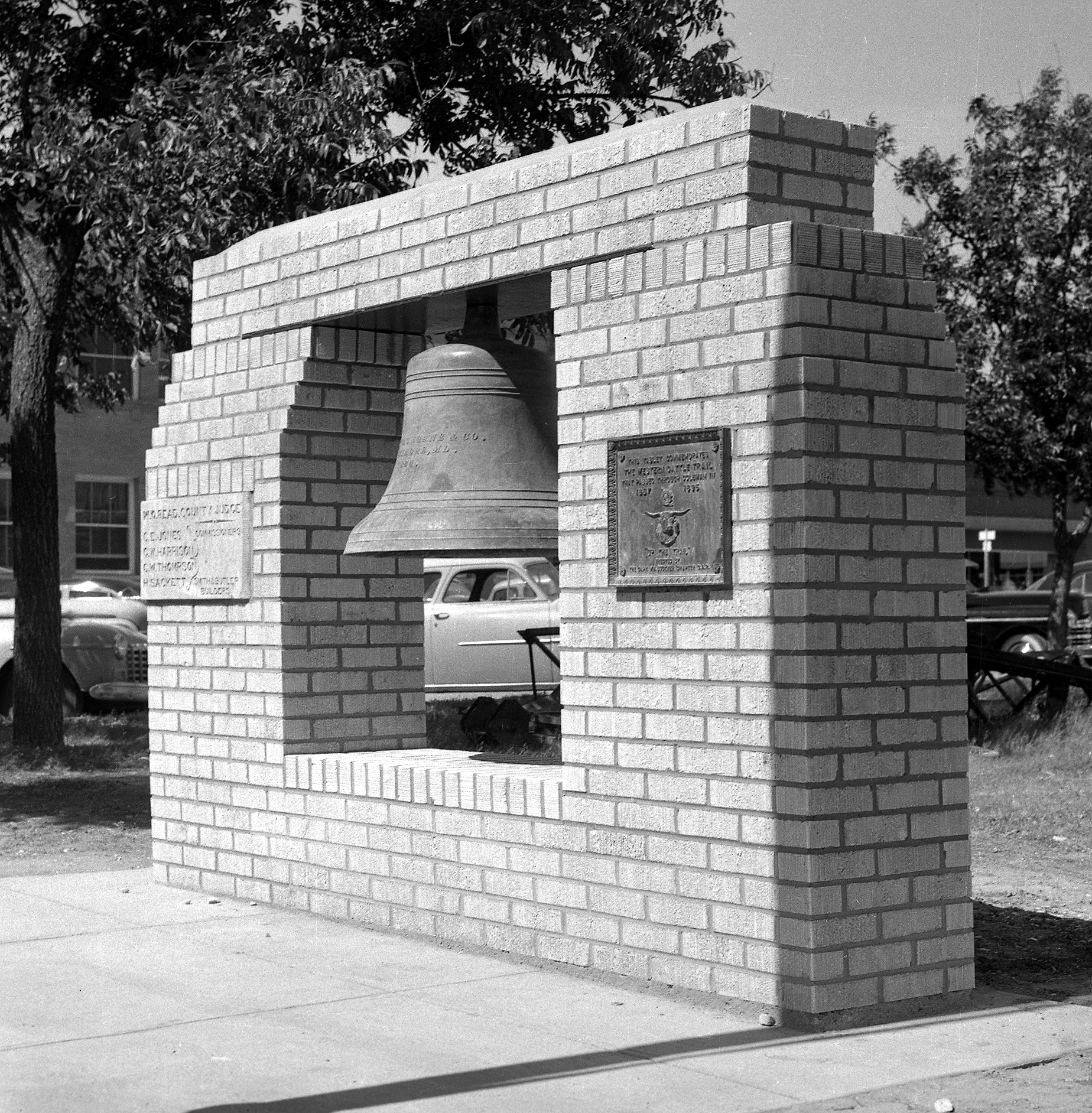 Structure fashioned to incorporate the Western Trail plaque (from 1952 to 1954), along with the cornerstone of the old courthouse and the great iron bell that had hung in its belfry since 1884. The structure remained, but the Western Trail Marker was removed and placeed on the new stone. There was one supplemental
problem following the building of the
courthouse. On the lawn of the new
courthouse, a brick structure was fashioned to
incorporate the Western Trail plaque, along with
the cornerstone of the old courthouse and the
great iron bell that had hung in its belfry
since 1884. However, the local Captain
William Buckner Chapter of the Daughters of the
American Revolution protested the moving of the
Western Trail plaque from the stone it had been
on to the brick memorial structure. The
plaque, which had been dedicated by the local
DAR chapter, had been placed on the courthouse
lawn in 1925 on a stone selected at Camp
Colorado. DAR Regent, Mrs. Lewis Jobe,
located the original stone in a dump of debris
from construction on the courthouse. M. V. Ray
had been hired to pick up the heavy stone,
weighing more than 1,000 pounds, and keep it to
be returned later to the courthouse. Ray
had left it in his yard and was out of town for
several days. When he returned it was
missing from his yard. The stone was not
located, even after a $100 reward was offered
for its return. In October 1953, the
search for the stone was abandoned and a search
for a new stone began. A DAR committee
made up of Mrs. Lewis Jobe, Mrs. Sumter
Weatherred and Mrs. Lucien White picked a native
stone to be shaped into a marker for the Western
Trail plaque by stonecutter W. A. Finlay.
In May 1954, this stone was dedicated by the
DAR. In later years, the culprits of the
stone theft admitted what they had done, but the
second stone remains on the courthouse lawn
today, and an empty place on the bell memorial
remains there. In 1964, the marker was
recognized by the Texas State Historical Survey
Committee as an Official Non-State Historical
Marker, commemorating the Western Trail that
passed through Coleman in 1887-1898.
Adams
—
Coleman County Atoka
—
Coleman County - Cemetery —
7083001405 CN-C014
Atlas Number 7083001405 Atoka
Cemetery
— Coleman County - Historical Marker —
5083000232 Settlement of this
area began in the 1850s with the establishment
of Camp Colorado, a United States cavalry
outpost. At the outbreak of the Civil War the
camp was occupied by Texas State Troops and
Texas Ranger units. The existence of the camp
spurred permanent settlement in the area, and
many families moved here from the southern
United States after the Civil War. The
settlers established farms and ranches, and
the Atoka community included a general store
operated by D.A. Parker and S.N. Edenborough,
a combination church/school building, and a
cotton gin built by D.A. Parker. This cemetery
was established in 1880 on land deeded by C.E.
Bush. Among the early pioneers buried here are
the Rev. Hugh Martin Childress, Sr., a former
Texas Ranger and Republic of Texas soldier;
his son, Elisha Childress, who served as the
first Coleman County sheriff; veterans of the
Civil War; and several workers killed in an
explosion that occurred during the
construction of a Santa Fe Railroad bridge
across Jim Ned Creek in 1910. The cemetery,
which is maintained by an association of
descendants of those buried here, is one of
the few physical reminders of the Atoka
community and its pioneer settlers. (1996)
Marker Number 232
Atlas Number 5083000232
Blair House — Coleman
County Brown Ranch — Coleman County Burkett Cemetery — Coleman County Camp Colorado, C.S.A. — Coleman
County Camp Colorado Cemetery — Coleman
County Camp Colorado Guard House — Coleman
County Camp Colorado Replica — Coleman
County Centennial School — Coleman
County Cleveland-Anson House — Coleman
County Coleman County — Coleman County Coleman County Courthouse — Coleman
County Coleman County Jail — Coleman
County Colonel James E. McCord — Coleman
County D. A. Parker House — Coleman
County Emma Daugherty Banister — Coleman
County First Christian Church of Santa Anna —
Coleman County Five Ashes — Coleman County Glen Cove Cemetery — Coleman
County Gouldbusk Cemetery — Coleman
County Herring Cemetery — Coleman County Hill — Coleman County John R. Banister — Coleman County Jordan Cemetery (NOTE: originally on
Lamar Turner Ranch, in 1988 was Pevehouse
Ranch), now 2023 on La Vista Ranch) — Coleman
County - Cemetery —
7083002205 Kin Elkins Home — Coleman County Leaday — Coleman County Midway — Coleman County Mr. and Mrs. W. P. Williams — Coleman
County Mrs. J. A. B. Miller Public Library
Building — Coleman County Mt. View Cemetery — Coleman
County Old Rock House — Coleman County Old Valera — Coleman County Richard A. Pauley — Coleman
County Robert M. Coleman — Coleman
County Rough Creek — Coleman County Route of Old Military Road — Coleman
County Ruins of Camp Colorado — Coleman
County Santa Anna — Coleman County Santa Anna, C.S.A. — Coleman
County Santa Anna Cemetery — Coleman
County Shields Cemetery — Coleman County
- Historical Marker —
5083011813 - The first community
in this vicinity began as a Baptist church
settlement founded in 1900. The vast ranch
land of the area was divided into lots
beginning about 1905. Early settlers called
the community "Double Gates" because there
were two gates on the road between the nearby
towns of Coleman and Brady. A watering hole
near the road also attracted travelers. L. L.
Shield built a general store and post office,
and the community was named for him. The
infant son of J. T. and L. A. (Dillingham)
Gilbreath died in June 1908 and became the
first person to be interred on land set aside
for a Shield community cemetery. One acre of
land including the grave was donated to County
Judge T. J. White, trustee, in December of
that year. The cemetery gradually took on the
name Shields. The earliest graves here are a
testimony to the difficulty of pioneer life:
almost half the 37 people interred during the
first ten years of the cemetery's operation
were children younger than three years of age,
two more were teenagers and four were under
the age of twenty-five. Only one person more
than fifty years of age was buried during this
period: Susan Winkler McGinnis Godwin died in
1913 at age eighty-two. Veterans of the Civil
War, World War I, World War II, and the Korean
War are interred here. Six graves in the
northwest corner of the cemetery are believed
to be those of Catholic Mexican Americans. The
Shield community thrived for a time, and many
of its most influential citizens are interred
on this site. Though the community declined
after World War II, Shields Cemetery remains
as a chronicle of its people. (1999) Incising
on base: In memory of Susan Winkler McGinnis
Godwin Shields Cemetery — Coleman
County - Cemetery —
7083002405 – (NOTE:
This marker is apparently for the same
one as above, but with a different number) Silver Valley Cemetery — Coleman
County Site of Flat Top Settlement — Coleman
County Stewardson — Coleman County Talpa Cemetery — Coleman County The Rock House on Day Ranch — Coleman
County Town of Trickham — Coleman County Trickham Cemetery — Coleman
County Turner House — Coleman County Valera — Coleman County Valera Cemetery — Coleman County Voss — Coleman County Walker — Coleman County Western Trail Marker — Coleman
County White Chapel
Cemetery — Coleman County – 1999 - Coleman
County was organized in 1867. The landscape in
this area included high grasses, pecan and
live oak trees. Deer, turkey, bear and
antelope roamed freely. Into this wilderness
came such pioneers as John Thomas and Julia
Gowens Hamilton, Julia's parents G. A. and
Rachel Ann Berryman Gowens, and Rachel's
father Benjamin Berryman and his family. The
group passed Coleman, choosing instead to
settle in this locality. The village of White
Chapel grew from the efforts of these settlers
and their neighbors. The earliest interment on
this burial ground was that of Joseph Shipman,
who died in 1884. When land was deeded for a
school that year, the cemetery was established
on the same site. The school, cemetery and
community were known as White Chapel. The Rock
Crusher School District was created in 1916
and included White Chapel District #44, but
White Chapel voters rejected consolidation in
1917. The White Chapel Baptist Church was
moved to the school grounds in 1930. In 1936
the Centennial High School District was formed
and older grade levels were consolidated into
the new organization. In 1951 all White Chapel
students were consolidated into the Centennial
District. In 1952 the cemetery was granted a
separate deed from the school. Pioneer family
names represented in the cemetery are
Berryman, Brooks, Collier, Fenton, Gowens,
Jameson, Kelley, Hamilton, Nelson, Saunders
and Stacy. Three Civil War veterans and
several members of the U. S. Armed Forces are
interred here. The White Chapel Cemetery
remains a chronicle of the early settlers of
this wilderness. (1999) Whon Cemetery — Coleman
County (NOTE – not shown on map) unknown (Trickham) — Coleman
County unknown grave (Trickham) — Coleman
County |